Project Highlights | |
|---|---|
| Location: | Central Namibia |
| Ownership: | Up to 100% - EPL Specific |
| Project Status | Exploration |
- Covers highly prospective areas of the Damara Mobile Belt for Gold
- Overlies similar lithologies and structures as the known Namibian Gold mines (QKR’s Navachab) as well as Osino Resources’ recent Twin Hills discovery (±2 Moz Au
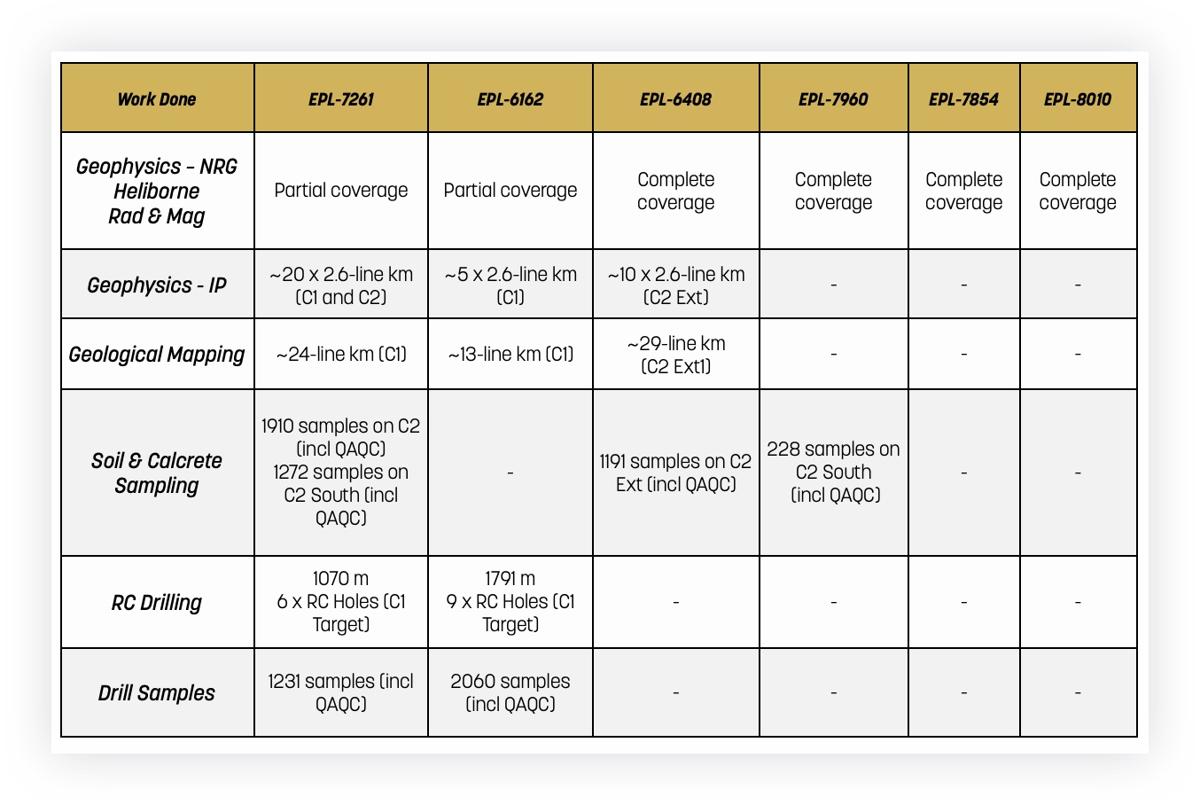
- 4,956 line km’s of Helimag flown
- 7 Au targets (C1 to C7) identified from Helimag
- 102.25 line-km IP surveyed across targets C1 and C2
- 2,861 m of RC drilling completed over target C1
- Four holes intersected significant Cu-Ag-Au mineralization (C1L14-4-3, C1L14-4-3A, C1L14-4-3B and C1L14-4-3C)
- 1.2% Cu over 40 m (C1L14-4-3B: 29 – 69m) / 11.2 g/t Ag over 42 m (C1L14-4-3B: 27 – 69m) / 1.5 g/t Au over 11 m (C1L14-4-3: 11 – 22m)
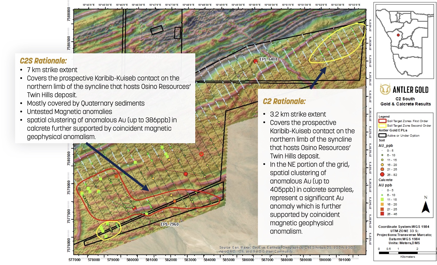
- 4,380 Soil and calcrete samples collected (incl. QA/QC)
- 10 km Au in soil and calcrete anomaly identified (C2 Ext1) and (C2 S) supported by coincident magnetic geophysical anomalism.
Drilling Results on C1 (EPL6162)
- 2,861 m of RC drilling completed over target C1 Target in 2021 (EPL6162)
- Four holes intersected significant Cu-Ag-Au mineralization (C1L14-4-3, C1L14-4-3A, C1L14-4-3B and C1L14-4-3C)
- 1.2% Cu over 40 m (C1L14-4-3B: 29 – 69m) / 11.2 g/t Ag over 42 m (C1L14-4-3B: 27 – 69 m) / 1.5 g/t Au over 11 m (C1L14-4-3: 11 – 22 m)
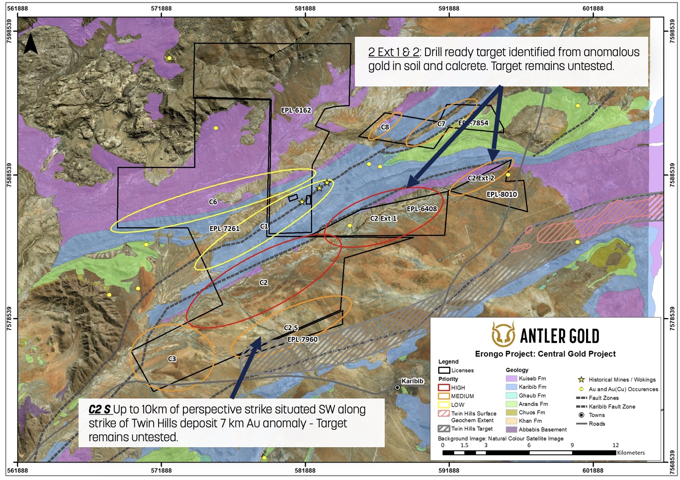
Drilling Ready Targets C2ext. & C2 South
- Priority 1: C2 Ext1 (EPL-6408) and C2 Ext2 (EPL-8010) and C2 South (C2S) (EPL7261/EPL7960) HIGH priority targets
- Drill ready target identified from anomalous gold in soil and calcrete on C2 Ext1 target
- C2 S target is situated SW along strike of Twin Hills deposit (assays pending) sharing same structural setting
Work Done to Date
Significant Untested Potential
6 Exclusive Prospecting Licenses
- Total Area: 25,766 Ha
- High Priority: C2 South (C2S) (EPL7261/EPL7960) and C2 Ext1 (EPL-6408) and C2 Ext2 (EPL-8010) and
- Drill ready target identified from anomalous gold in soil and calcrete on C2 Ext1 target
- C2 S target 7 km Au anomaly situated SW along strike of Twin Hills deposit sharing the same structural setting
C2 Main, C2 South (EPL-7960) and C2 NE Extensions (Ext1 and Ext2) (EPL-6408 and EPL-8010) represent significant potential to host mineralization and remains un-drill tested.
- The regional-scale Fault Zones (Karibib and Kranzberg) have played a substantial role in gold mineralization (Twin Hills, Osino Resources).
- The Karibib – Kuiseb litho contact represents an important regional mineralization target. (Twin Hills, Osino Resources).
- Identified a significant 7-km anomalies range of 10 to 405 ppb Au (background of less than 5ppb)
- Located directly SW from Osino Resources Twin Hills Discovey (3.1m oz)
Geology of the Erongo Gold Project
The Erongo Gold Project is hosted by rocks within the Southern Central Zone of the Damara Orogen. This terrane comprises mid Proterozoic granitic basement inliers, overlain by metamorphosed late Proterozoic arkoses, shelf carbonates, turbidites and minor volcanic rocks that have been intruded by numerous granites and pegmatites.
The bulk of the Project area is underlain by meta-sedimentary rocks of the Nosib Group meta-arkoses (Etusis Formation) or the stratigraphically younger Swakop Group marine carbonates and meta-turbidites comprising the Arandis Formation (biotite schist, minor quartz schist calc-silicate rock and amphibolite), the Karibib Formation (dominantly dolomitic and calcitic marbles with minor calc-silicate) and the overlying Kuiseb Formation (schistose quartz feldspar mica meta-greywacke and meta-pelite). Glaciogenic mixtites of the Chuos and Ghaub Formations have limited exposure in the project area. The Swakop Group sediments have been intruded by a series of syn-, late-syn- and post-tectonic granite and pegmatite bodies.
The Erongo Gold Project is straddled by the magnetically defined regional scale Omaruru and Welwitschia Lineaments in the west and the Abbabis and Erongo Lineaments in the east. These lineaments are interpreted to be important tectono-stratigraphic boundaries associated with changes in sedimentology, structure and type of granitic intrusion observed in the Damara Orogen and have known association and control with uranium and other forms of mineralization. The structural setting of the Project area is fairly complex with sediments deformed during poly-phase deformation and metamorphosed to upper greenschist-amphibolite facies.
The structural geology of the Erongo Gold Project area is dominated by features typical of the Southern Central Zone of the Damara Belt; Abbabis Basement and/or basal Damara meta-sedimentary rocks in the cores of dome and anticlinal structures and regional synclinal structures with thick packages of Kuiseb Formation schists occupying these synclines. The larger, earlier folds tend to have fold axes with a north-east, south-west direction, parallel to the Omaruru Lineament, and these were subsequently deformed into open basin and dome structures or boudinaged in the more competent lithologies. Later cross cutting lineaments parallel to the Welwitschia Lineament are also evident. These NNE trending structures appear to be loci for mineralised fluid movement.
The gold mineralization in the Damara Belt in general, including Otjikoto, Navachab, Ondundu, Onguati and Twin Hills all share various similarities including stratigraphic position and relationship to regional and local structure. A significant relationship is observed between gold and quartz - sulphide veins hosted dominantly in schists and calc-silicate rocks and to a lesser extent within marbles and dolomitic marbles, as seen at Navachab (and associated satellite deposits). These discoveries and the historical gold deposits and occurrences, in general, highlight the Central and Northern Zones of the Damara Orogen, as a prime target for further discovery.
Antler recently discovered the previously unmapped Kranzberg Fault Zone. The Kranzberg Fault Zone is an arrangement of ENE and NNE trending thrusts and faults that can be traced for over 50 km and may have developed by reactivation of the larger Omaruru, Onguati and Abbabis Lineaments during the transpressional D3 / D4 Damaran deformation. Structures associated with the D3 / D4 event have been shown to be important conduits for hydrothermal fluids and highly prospective for gold mineralisation, as demonstrated by the Navachab Gold Mine and Osino's Twin Hills Project.
This fault zone is parallel to and shares many similarities to the Karibib Fault Zone which hosts Osino's Twin Hills Project. The associated Kranzberg Gold Trend, with peak historical rock assay values up to 80 g/t, stretches across Antler's Central Project from the Kranzberg Dome, in the southwest, through Antler's EPL 6162 and 7261 and around Antler's Etiro Dome property (EPL6550) in the northeast. In total, Antler holds approximately 20 km of strike length along this gold trend.
The Kranzberg Gold Trend contains a number of historical smaller scale mines and prospects including Onguati, Brown Mountain and Western Workings (all previously worked during the 1950's and 1960's). In addition, a number of significant gold in soil and gold in rock anomalies have been historically defined. These gold anomalies are located along the Kranzberg Fault Zone within Antler's EPLs 7261, 6162 and 6550 and contain gold in soil assays of up to 7000 ppb gold and gold in rock assays of up to 80 g/t gold, all against a background of less than 5 ppb gold. Note these results are historic and have not been verified by Antler. The historic mines, prospects and soil anomalies occur in association with folds; faults; fault splays and jogs; and late- to post-tectonic leucogranite intrusions, all typical of fertile orogenic belts.
The Kranzberg Gold Trend is located in the saddle region of a moderate-to-gently inclined doubly plunging anticline with associated large-scale, deep penetrating, crustal structures of the Kranzberg Fault Zone. Interpretation and delineation of this fault zone was only made possible by Antler's geophysicists through reprocessing of the Government regional aeromagnetic data taking cognisance of the negative impact of magnetic attenuation due to increased survey ground clearance required over the Erongo Mountains in the north of the Central Project. The Erongo Mountains are a post-Karoo aged volcanic caldera that tower 1,000 meters above the flatter plains of the Central Project. Downward continuing and reprocessing the data to mitigate the impact of non-ideal survey heights in conjunction with the initial field visit has resulted in the identification of this previously unrecognized but significant Kranzberg Fault Zone.
Forward Looking Statements
Information set forth in this presentation contains forward-looking statements that are based on assumptions as of the date of this presentation. These statements reflect management's current estimates, beliefs, intentions and expectations. They are not guarantees of future performance. Antler Gold Inc. (“Antler Gold”, “Antler” or the “Company”) cautions that all forward-looking statements are inherently uncertain, and that actual performance may be affected by a number of material factors, many of which are beyond Antler’s control. Such factors include, among other things: risks and uncertainties relating to metal prices, changes in planned work resulting from weather, logistical, technical or other factors, the possibility that results of work will not fulfill expectations and realize the perceived potential of Antler Gold's mineral properties, uncertainties involved in the interpretation of drilling results and other tests, the possibility that required permits may not be obtained in a timely manner or at all, risk of accidents, equipment breakdowns or other unanticipated difficulties or interruptions, the possibility of cost overruns or unanticipated expenses in work programs, the risk of environmental contamination or damage resulting from the exploration operations, the need to comply with environmental and governmental regulations and the lack of availability of necessary capital, which may not be available to Antler Gold acceptable to it, or at all. Antler Gold is subject to the specific risks inherent in the mining business as well as general economic and business conditions. Accordingly, actual and future events, conditions and results may differ materially from the estimates, beliefs, intentions and expectations expressed or implied in the forward-looking information. Except as required under applicable securities legislation, Antler Gold undertakes no obligation to publicly update or revise forward-looking information. Antler Gold does not intend, and does not assume any obligation, to update these forward-looking statements, except as required under applicable securities legislation. For more information on Antler Gold, readers should refer to Antler Gold's website at www.antlergold.com.
Qualified Person
The technical and scientific information in this presentation has been reviewed and approved by Oliver Tors, B.Sc (Hons)., Exploration Manager of the Company, who is registered Professional Natural Scientist with the South African Council for Natural Scientific Professions (Pr. Sci. Nat. No. 120660) who is a Qualified Person as defined by NI 43-101. Mr. Tors is an employee of Antler Gold Inc. and is not independent of the Company under NI 43-101.